Annapurna Circuit Trek
A journey shaped by the landscapes, people and experiences of Nepal.
Offered by Abhiwadan Expedition Holidays Pvt. Ltd.
 NEPAL · TRAVEL EXPERIENCES
Discover the journey
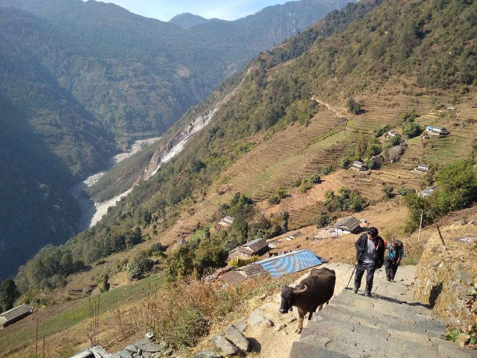
The Annapurna Circuit is one of Nepal's most well-known and challenging treks. This well-known trip meanders along the foothills of the Himalayas and crosses high passes, providing breathtaking mountain vistas all along the way. Scenery and Landscape The Annapurna Circuit offers breathtaking views of nature. Trekkers travel through glacial habitats, subtropical woodlands, and paddy areas with terraced rice fields. Three peaks over 8,000 meters in height—Dhaulagiri (8,176 meters), Manaslu (8,156 meters), and Annapurna I (8,091 meters)—as well as the Annapurna Massif (I to IV) will be visible. There are many further peaks between 6,000 and 7,000 meters. Where Does The Annapurna Circuit Start and End? The journey starts in Besisahar, a town that can be reached by car in 7-8 hours from Kathmandu, and it ends in the Kali Gandaki Gorge, which is thought to be the world's tallest gorge and divides the peaks of Dhaulagiri (8,176 meters) in the west and Annapurna (8,091 meters) in the east. For acclimatization purposes, the circuit is typically completed on an anti-clockwise track that goes around the Annapurna Massif. It leads trekkers across central Nepal's Annapurna, Manang, and Mustang regions. How Long Is The Annapurna Circuit? It normally takes 16 to 20 days to complete the Annapurna circuit. Depending on whether you add a side trip to the Annapurna Base Camp and the Annapurna Sanctuary. Depending on when you opt to stop the journey or use transit, it travels anywhere from 150 to 240 kilometers. Route Details The trip reaches its highest point when it crosses the Thorung La Pass (5,416 meters), after which it descends to the village of Muktinath. From here, the Annapurna Circuit trekking experience has been significantly impacted by the road construction activity (2004–2008–2009). The road on both the Western (Pokhara-Muktinath) and Eastern (Chame-Manang) sides of the circuit has had a detrimental effect on trekking tourism, the Nepalese government has realized. As a result, they have developed some NATT-trails or New Annapurna Trekking Trails. Trekkers are directed away from the uncomfortable and dusty roads by these NATT trails, which are marked with blue and white or red and white. The detours make for a far more enjoyable trekking experience.
Journey at a glance
Day 01: Arrive Kathmandu — When you arrive at Tribhuvan International Airport, your guide will give you a traditional Nepali welcome. Transfer to Hotel: After a relaxing ride to your Kathmandu hotel, take some time to clean yourself and unwind. Meet your guide in the hotel lobby for a warm welcome and an overview of your schedule. Welcome briefing and orientation will follow. They will answer any questions you may have and give you important information about Nepal, regional customs, and safety precautions. Overnight stay. Day 02: Kathmandu - Besisahar — Drive a bus for 175 kilometers from Kathmandu (1,300 meters) to Besisahar / Khudi (820 meters). The route meanders through rural villages and takes between 7 and 8 hours. Typically, the Annapurna Circuit begins in Besisahar, an hour's hike from Khudi. Some tour guides will transport you to Khudi and start the trek there. Day 03: Trek from Besisahar (820 meters) to Khudi and onto Bahundanda (1,310 meters) — Trekking routes lead from Besisahar (820 meters) to Khudi and then on to Bahundanda (1,310 meters). Some operators have begun using new paths that avoid the road because the development on the road has affected this usual route. Go instead to Sikrung (2,200 meters), the settlement. The second requires a pretty arduous ascent to a considerable altitude. The Annapurna hiking experience is more authentic, though, thanks to this. A 6-7 hour hike is to be anticipated. Day 04: Trek from Bahundanda (1,310 meters) / or Sirung (2,200 meters) to Jagat (1,300 meters) or potentially Chamje (1,410 meters) — Trek from Sirung (2,200 meters), Bahundanda (1,310 meters), Jagat (1,300 meters), or perhaps Chamje (1,410 meters). You would hike to Ghermu (1,130 meters), then on to Jagat, on Day 4 if you took the conventional route to Bahundanda. You might spend the night here or hike an arduous hour up to Chamje (1,410 meters). Instead of staying the night in Jagat, which is a filthy and busy village, we advise choosing Chamje. If you stopped at Sikrung on day 4, you'll probably take a route via Syange (1,100 meters) to Jagat and then ascend to Chamje. Early in the day's trekking, you can expect to experience beautiful rice-terraced scenery and vistas of the Manaslu Range. Day 05: Jagat / Chamje (1,300 / 1,410 meters) to Dharapani (1,960 meters) — From Jagat or Chamje (1,300 or 1,410 meters) to Dharapani (1,960 meters), hike. As you hike farther north into the Manang region, you will pass through rhododendron forests before coming to agricultural fields of corn and potatoes. eventually arrive in Tal, a charming town at 1,700 meters. To reach the settlement of Dharapani (1,960 meters), you must go another 6 kilometers (around 3 hours) via Karte from Tal. Day 06: Dharapani (1,960 meters) to Chame (2,710 meters) via Bagarchap and Danakyu, and then either along the lower trail or upper trail to Koto (2,640 meters) — Trek from Dharapani (1,960 meters) to Chame (2,710 meters) through Bagarchap and Danakyu, and from there, choose to go to Koto (2,640 meters) by either the lower path or upper trail. You must hike for another hour from Koto to the bustling settlement of Chame. Some hikers and guides choose to spend the night in the more sedate settlement of Koto. You'll get some fantastic views of Annapurna II and IV as well as Lamjung Himal on this pretty challenging hiking day. Day 07: Chame (2,710 meters) to Pisang via Bhratang (2,850 meters) and Dhukur Pokhari (3,240 meters) — Trekking from Chame (2,710 meters) to Pisang (3,240 meters) through Bhratang (2,850 meters) and Dhukur Pokhari. In order to reach Upper Pisang (3,310 meters) or Lower Pisang (3,250 meters) for an overnight stay, the trail splits at Dhukur Pokhari. Rejoining the upper path on day 8 is highly advised if you choose to travel the latter to Lower Pisang. Possibly the nicest views of the entire Annapurna Circuit can be seen from here. Day 08: Trek using the upper trail from Pisang (3,310 meters) to Manang (3,450 meters) via Ghyaru (3,730 meters), Ngawal (3,680 meters), Humde (3,330 meters and Bhraga (3,450 meters) — From Pisang (3,310 meters) to Manang (3,450 meters), go along the higher trail via Ghyaru (3,730 meters), Ngawal (3,680 meters), Humde (3,330 meters), and Bhraga (3,450 meters). In this section of the Circuit, the picturesque villages and mountain views are among the Circuit's best features. Before the last leg to Manang, it is worthwhile to visit the Barge monastery. Day 09: Day of acclimatization in Manang — One of the major towns on the Circuit is Manang. Many hikers use this chance to spend a day in the town relaxing and acclimatizing. Trekkers frequently take quick trips to places like Gangapurna Lake and Bhojo Gompa, a Buddhist learning fortress. Day tours are also available within the city. You might want to think about stopping by the Himalayan Rescue Association's offices to hear a presentation on the dangers of high altitude. Day 10: Manang northwest out of the Marshyangdi Valley and up to the small village of Yak Kharka (4,110 meters) — Trek from Manang northwest through the Marshyangdi Valley and up to Yak Kharka (4,110 meters), a small settlement. If you haven't already, you might begin to experience the affects of altitude today. Some hikers carry on toward the hamlet of Letdar (4,200 meters). There aren't many teahouses in either of these villages. Day 11: Yak Kharka (4,110 meters) to High Camp (4,850 meters) — To reach High Camp (4,850 meters), hike from Yak Kharka (4,110 meters). This day is fairly challenging and steep. At Thorang Phendi (4,450 meters), some tour companies will make an overnight stop. This is a wise choice if hikers are having trouble with the altitude. However, we think that going on to High Camp is better. This is due to how much shorter and simpler the treks the following day are to Muktinath (3,800 meters). The lodging options and amenities in High Camp and Thorang Phendi are both excellent. Please be aware that moving on to High Camp will require you to spend the night at a high altitude, which is not recommended if you have signs of acute mountain sickness (AMS). Day 12: High Camp (4,850 meters) across the Thorung Pass (the highest point on the trek at 5,416 meters) and then back down to Muktinath (3,800 meters) via Charabu (4,230 meters) — Cross the Thorung Pass, the highest point on the route at 5,416 meters, starting at High Camp (4,850 meters). Then, via Charabu (4,230 meters), you descend to Muktinath (3,800 meters). Get ready for a challenging, arctic day of hiking. Trekking poles are useful on the steep descent from Thorung Pass. Muktinath is a significant Hindu and Buddhist pilgrimage site (see the Vishnu Temple), yet it lacks much in the way of personality. Your operator may require you to spend the night in Muktinath. The Bob Marley Guesthouse in the heart of town is a fantastic choice for independent hikers! Day 13: Muktinath (3,800 meters) to Marpha (2,665 meters) via the awesome village of Kagbeni (2,800 meters) — Trek from Muktinath (3,800 meters) to Marpha (2,665 meters), passing through the magnificent Kagbeni town (2,800 meters). We advise using a jeep to avoid the uncomfortable dusty roads from Kagbeni to Jomsom. The route to Marpha via the new NATT-trail, which takes two hours longer than the road alternative, can be joined once you reach Jomsom. The center of Nepal's apple area, Marpha, is well known. When you have a chance, try the apple brandy. Day 14: Marpha (2,665 meters) to Kalopani (2,530 meters), via Chokhopani, and continue to Kokhethanti to avoid the road — To bypass the road, hike from Marpha (2,665 meters) to Kalopani (2,530 meters), then continue to Kokhethanti. From Marpha to Tatapani, some trekkers take a vehicle Day 15: Kolapani (2,530 meters) to Tatapani (1,200 meters) — To reach Tatapani (1,200 meters), hike from Kolapani (2,530 meters). By following a brand-new NATT-trail (shown in red and white), you can stay off the road and ascend steeply before connecting a route that will lead you through the settlements of Kopochepani, Rupsechhahara, Dana, and ultimately Tatapani. Day 16: Tatapani (1,200 meters) to Ghorepani (2,870 meters) — Trek up through the settlements of Ghara, Sikha, and Chitre from Tatapani (1,200 meters) to Ghorepani (2,870 meters). Most likely, you'll spend the night at Ghorepani to prepare for an early start the following day. Day 17: Ghorepani (2,870 meters) up Poon Hill (3,870 meters) and back down to Tadapani (2,710 meters) — Trek from Ghorepani (2,870 meters) to Tadapani (2,710 meters), then up Poon Hill (3,870 meters). You'll set out on your journey this morning early in order to ascend Poon Hill in time to see the magnificent dawn. The nearby rice terraces, Annapurna, and Dhaulagiri massifs are all illuminated by the first light. After descending to Tadapani for an overnight stop, the traditional Annapurna Circuit trek continues. Note: According to legend, the hill opposite in the direction of Chomrong offers an equally stunning (if not better) view without any congestion problems, as opposed to climbing Poon Hill. Day 18: Day 09 — Trekking from Tadapani (2,710 meters) to Naya Pul (1,070 meters) via Gandruk, followed by a quick bus journey back to Pokhara. The Annapurna Circuit has come to an incredible 18-day conclusion. It is feasible to go from Ghorepani to Phedi through Landruk, but it adds an extra two days to the trip compared to taking the direct route from Ghorepani to Naya Pul. Day 19: Pokhara - Kathmandu — Drive back to Kathmandu. Day 20: Departure — We will drop you at Airport, According to your flight time.
Day-by-day itinerary
Day 10Manang northwest out of the Marshyangdi Valley and up to the small village of Yak Kharka (4,110 meters) —
Confirm daily arrangements with the provider.
Day 11Yak Kharka (4,110 meters) to High Camp (4,850 meters) —
Confirm daily arrangements with the provider.
Day 12High Camp (4,850 meters) across the Thorung Pass (the highest point on the trek at 5,416 meters) and then back down to Muktinath (3,800 meters) via Charabu (4,230 meters) —
Confirm daily arrangements with the provider.
Day 13Muktinath (3,800 meters) to Marpha (2,665 meters) via the awesome village of Kagbeni (2,800 meters) —
Confirm daily arrangements with the provider.
Day 14Marpha (2,665 meters) to Kalopani (2,530 meters), via Chokhopani, and continue to Kokhethanti to avoid the road —
Confirm daily arrangements with the provider.
Day 15Kolapani (2,530 meters) to Tatapani (1,200 meters) —
Confirm daily arrangements with the provider.
Day 16Tatapani (1,200 meters) to Ghorepani (2,870 meters) —
Confirm daily arrangements with the provider.
Day 17Ghorepani (2,870 meters) up Poon Hill (3,870 meters) and back down to Tadapani (2,710 meters) —
Confirm daily arrangements with the provider.
Day 18Day 09 —
Confirm daily arrangements with the provider.
Day 19Pokhara - Kathmandu —
Confirm daily arrangements with the provider.
Day 20Departure —
Confirm daily arrangements with the provider.
Essential trip information
Before you go
Extra Info
Fitness & eligibility
4
Meeting point
ktm
There's more to experience.
Discover another journey, explore local experiences or find a place to stay.